
Discovering the Edwards Plateau in Texas: A Unique Ecological Gem
The Edwards Plateau Texas is one of the state's most distinctive geographical features, often celebrated for its rugged beauty and vital natural resources. Spanning a vast area in south-central and west-central Texas, the Edwards Plateau region of Texas forms a crossroads between Central, South, and West Texas. This elevated limestone plateau is a haven for unique ecosystems, clear springs, and rolling hills that define the iconic Texas Hill Country.
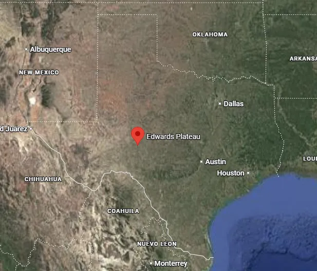
Where Is Edwards Plateau Located?
If you've ever wondered where is Edwards Plateau located, it occupies a large portion of central Texas, bounded by the Balcones Fault to the south and east, the Llano Uplift and Llano Estacado to the north, and the Pecos River and Chihuahuan Desert to the west. Extending east of the Pecos River and west of the Colorado River, this region covers parts of over 40 counties, making it a significant part of the Great Plains' southernmost extension.
This Edwards Plateau map illustrate its expansive reach.
Edwards Plateau Geography and Landscapes
The Edwards Plateau geography is characterized by uplifted limestone formations dating back to the Cretaceous Period, resulting in a mix of flat-topped mesas in the west and deeply eroded hills in the east. Known for its karst topography, the region features caves, sinkholes, and abundant springs. Scenic rivers like the San Saba, Nueces, Frio, Guadalupe, and Devil's carve through the terrain, creating stunning canyons and clear waterways.
Cities in Edwards Plateau and Major Urban Centers
While much of the plateau remains rural with a focus on ranching and agriculture, several cities in Edwards Plateau serve as gateways to its natural wonders. Edwards Plateau major cities on the edges include Austin and San Antonio, which mark the eastern and southern boundaries along the Balcones Escarpment. Interior towns like San Angelo, Kerrville, Fredericksburg, and Del Rio provide regional hubs for residents and visitors alike.
The Vital Edwards Plateau Aquifer and Related Systems
At the heart of the region lies the Edwards Plateau aquifer system, crucial for water supply in this semi-arid landscape. The renowned Edwards Aquifer forms along the plateau's eastern edge, one of the most prolific artesian aquifers globally, supporting millions with drinking water, agriculture, and industry.
Key map of the Edwards Aquifer and related systems:
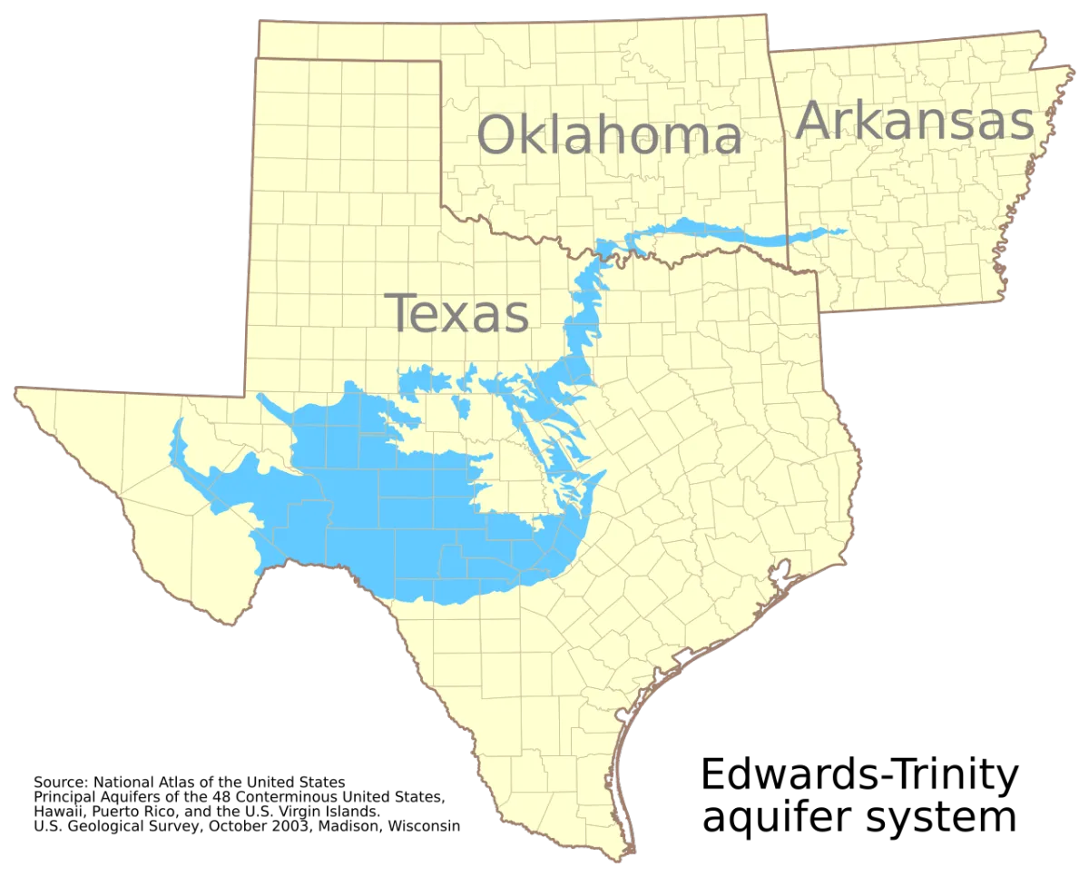
Overlapping in parts is the Edwards-Trinity Aquifer, a major system underlying much of the plateau with limestone and sandstone layers, providing essential groundwater for irrigation and municipal use.
Edwards Aquifer History and Conservation
The Edwards Aquifer history traces back millions of years to ancient seas, with modern management beginning in the 1990s through entities like the Edwards Aquifer Conservation District and the Edwards Aquifer Authority, established to regulate pumping and protect flows.
Edwards Aquifer Pollution and Endangered Species
Concerns over Edwards Aquifer pollution from urban runoff and development highlight the need for vigilant protection. The aquifer is home to unique Edwards Aquifer endangered species, including the fountain darter and Texas blind salamander, which rely on pristine spring flows.
Preserving the Edwards Plateau: The Role of the Edwards Plateau Alliance
The Edwards Plateau's natural beauty, water resources, and ecological diversity face ongoing challenges from development pressures. Organizations dedicated to its stewardship play a critical role in safeguarding this irreplaceable region. The Edwards Plateau Alliance is a community-driven group focused on protecting the land, water, families, and environment of the Edwards Plateau. With education at the heart of its mission, the alliance informs the public about the impacts of large-scale infrastructure projects—such as high-voltage transmission lines—on the region's ranches, rivers, wildlife habitats, and water systems.
Through advocacy, community organizing, and calls for sustainable alternatives, the Edwards Plateau Alliance works to preserve the plateau's heritage and resources for future generations, emphasizing collective action to address threats like habitat fragmentation, soil erosion, and potential pollution runoff.
Education is at the heart of what we do.
Join Us in Protecting the Edwards Plateau
Our community is our greatest strength. Together, we can ensure that the natural beauty and resources of the Edwards Plateau are preserved for generations to come. Whether you're a landowner, an expert in the field, or simply someone who cares about the environment, there are many ways you can get involved.
Ways You Can Get Involved:
Ask Questions: Learn more about the devastating impact of Texas "green" alternative energy projects on land, water and air. Learn more about Texas green energy.
Tint your Ranch Red, Blue or Purple: Join our census and take a stand against the Water and Land Grab! Call your neighbors!
Stay informed: Follow us on social media and our website to stay updated on the latest research and community events.
How You Can Support Us
There are many ways you can help The Edwards Plateau Alliance continue its work:
Donate: Your financial support allows us to continue our educational outreach and advocacy efforts. We are a 501(c)3 organization, and as such, your donations qualify as charitable deductions.
Volunteer: Join us in organizing local events or contributing content to our website.
Spread the word: Share the mission with your friends, family, and social media networks to help us reach more people.
Together, we can make a difference and ensure that the Edwards Plateau remains a thriving, vibrant part of Texas for generations to come.
24 The Lord bless thee, and keep thee:
25 The Lord make his face shine upon thee, and be gracious unto thee:
26 The Lord lift up his countenance upon thee, and give thee peace.
Numbers 6:24-26
Ezekiel 33:6
Nehemiah 6:9, Samuel 17:48-50, John 4:34
Ephesian 2:8, Gospel Message HERE
Follow Us - Alliance Social Media:
© The Edwards Plateau Alliance, Inc 2026
All Rights Reserved